


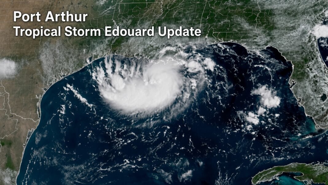
Tropical Storm Edouard is moving toward the Texas-Louisiana Gulf Coast Tuesday morning, with Port Arthur and nearby coastal communities watching the storm closely.
The National Hurricane Center said Edouard was about 90 miles southeast of Port Arthur, Texas, and about 65 miles south-southeast of Cameron, Louisiana, in its 4 a.m. CDT advisory Tuesday. The storm had maximum sustained winds of 40 mph and was moving west-northwest at about 8 mph.
Forecasters expect Edouard to strengthen during the day before reaching the northwestern Gulf Coast. The storm is forecast to move inland over southeast Texas tonight, where it should weaken quickly after moving away from the Gulf waters.
Port Arthur and Southeast Texas Are Watching the Storm
Port Arthur is among the communities that could see tropical-storm conditions as Edouard moves toward the coast.
The National Hurricane Center said tropical-storm conditions are expected to reach the coast within the warning area. Hurricane conditions are also possible in the area covered by the Hurricane Watch later Tuesday.
Read More:
For people living along the coast, the main concerns are strong winds, rising water, heavy rain and possible flooding.
Edouard is not expected to remain a tropical storm for long after moving inland. However, the short period over warm Gulf waters gives the system an opportunity to strengthen before landfall.
Storm Surge Could Cause Coastal Flooding
Storm surge is another important concern for the Texas and Louisiana coast.
Forecasters warned that rising water could move inland from the shoreline, especially during high tide. The highest water levels are expected near the coast and close to the right side of the storm’s center.
The forecast called for possible storm surge of about 3 to 5 feet from High Island, Texas, to the Vermilion/Cameron Parish line in Louisiana. Areas farther east, from the Vermilion/Cameron Parish line to Morgan City, Louisiana, could see about 1 to 3 feet of surge.
Residents in areas covered by a storm surge warning should follow instructions from local officials and be ready to move to a safer location if an evacuation order is issued.
Heavy Rain and Flash Flooding Are Possible
Rain could become one of the biggest problems from Edouard.
The National Hurricane Center forecast rainfall totals of about 3 to 6 inches across parts of the upper Texas coast and inland areas of east-central Texas. Some locations could receive as much as 9 inches.
Far southwest Louisiana could receive around 2 to 4 inches of rain.
Heavy rain over a short period can quickly create flooding, particularly in low-lying neighborhoods and areas with poor drainage. Flash flooding is possible, and some river flooding could also occur.
People should avoid driving through flooded roads. Even shallow-looking water can hide dangerous road conditions or damage underneath.
Watches and Warnings in Effect
Several weather alerts are in place along the Gulf Coast.
A Storm Surge Warning means dangerous coastal flooding from rising water is possible within the warning period.
A Hurricane Watch means hurricane conditions are possible in the affected area.
A Tropical Storm Warning means tropical-storm conditions are expected within the warning area.
The National Hurricane Center has advised people in affected areas to take the warnings seriously and follow instructions from local authorities.
Tornadoes Are Also Possible
Edouard may bring more than rain and wind.
Forecasters said a tornado or two could develop Tuesday afternoon or evening across parts of southwest Louisiana and southeast Texas.
Tornadoes can develop quickly during tropical systems, so residents should keep weather alerts turned on and know where they would go if a warning is issued.
What Happens Next?
The next several hours will be important for Port Arthur and other communities along the upper Texas coast.
Edouard is expected to continue moving west-northwest and then turn more toward the northwest. The National Hurricane Center expects the center to reach the northwestern Gulf Coast later Tuesday before moving inland over southeast Texas Tuesday night.
Forecasters are also watching the storm for additional strengthening before landfall. Once the center moves inland, rapid weakening is expected.
For residents in Port Arthur, Beaumont, Houston and nearby coastal communities, the safest approach is to keep checking official weather updates and local emergency information as conditions change.
Bottom Line
Tropical Storm Edouard is approaching the Texas-Louisiana coast and could become significantly stronger before reaching land Tuesday.
Port Arthur is about 90 miles northwest of the storm’s center in the latest National Hurricane Center advisory. Strong winds, storm surge, heavy rainfall, flash flooding and isolated tornadoes are the main concerns.
Residents should stay alert, secure loose outdoor items, avoid unnecessary travel during severe weather and follow any instructions issued by local officials.
The National Hurricane Center remains the primary source for official storm watches, warnings and forecast updates.


[…] Port Arthur Tropical Storm Edouard: Latest Sept. 1 Update […]